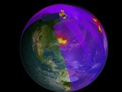
The tropospheric NO2 data that come from the Ozone Monitoring Instrument (OMI) aboard Aura is available in .kml files so that they can be viewed in Google Earth. An example of what the data look like is found on the right of this post. In order to get the data, go to the following url: http://hyperion.gsfc.nasa.gov/People/Wenig/OMINO2/NO2Trop.html
On this front page, you can choose monthly or daily NO2 .kml files. In order to select a particular month (for example, April 2007), click on the Google Earth icon. Your computer should give you a prompt to either open the file or save it. Save the file to your computer. Once the file is downloaded, open the .kml file in Google Earth. That’s all there is to it! Why do we care about tropospheric NO2, you might ask? In addition to being a cause of concern for your health, tropospheric NO2 is a precursor to ground level ozone. Ground level ozone is one of the major components of air pollution and causes respiratory problems in high concentrations. Around Goddard Space Flight Center in the summer, high concentrations of ground level ozone prompt “code” days. The EPA considers the 8-hour concentration of ozone and issues “Code Orange” or “Code Red” days when the concentrations exceed 101 or 151 ppm, respectively. Area public transit is free on Code Red days.
Just this week we had two code orange days in a row.